The Street Name Plate and the City That Learned to Label Its Routes
Street name plates reveal how cities made routes legible. Learn to read their placement, wording and changes as clues to urban history.
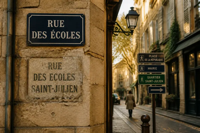
The common mistake with a street name plate is to treat it as decoration or a simple address aid; doing so misses the clues it offers about how a city learned to make its routes legible. Street name plates record a practical urban history: where officials thought a name needed to be seen, whose language counted, and how a route was meant to be understood.
To read one, start with the plate in front of you, then look outward to the junction, the buildings and any competing signs. The aim is not to date an object from its appearance alone, but to notice how naming and display help people orient themselves. A single plate can be a small entry point into a much larger system.
Start with the junction
Choose a place where one street meets another. Stand where a pedestrian would naturally pause to decide which way to go, and note whether the name plate is visible from that approach. A plate beside a corner, above a shopfront or fixed to a building may serve the same purpose, but each position reflects different constraints and habits.
Look for more than one sign. A junction may carry names for both streets, a directional arrow, a district name or a modern wayfinding panel. Notice which information is easiest to see before turning and which becomes visible only after you have crossed. This reveals how the city expects a newcomer to make a decision.
Also note what blocks the view: a tree canopy, a bus shelter, a projecting sign or parked vehicles. These are not necessarily evidence of poor planning; they show that street naming works within a crowded streetscape. The plate’s usefulness depends on its relationship to the route, not simply on whether it exists.
Read the wording
Write down the name exactly as displayed, including abbreviations, accents and any older spelling. A shortened form can make a sign easier to fit, while a full name may preserve a formal title or a locally recognised distinction. Compare the plate with nearby address numbers or signs, but do not assume that every spelling variation is an error.
Street names can describe a place, refer to a person, mark a former use or preserve a name inherited from an earlier settlement. The wording alone rarely settles which explanation applies. Instead, treat it as a question to investigate: does the name fit the street’s visible character, or does it seem to belong to a different layer of the city?
Pay attention to language as well. Some places display names in more than one language; others use a local-language form alongside a translated or standardised version. The arrangement, relative prominence and pronunciation marks can show how the city makes room for different audiences. Avoid treating one sign as a complete account of local identity; it is a public choice about what to display in a particular setting.
Follow the naming system
Walk a short stretch in both directions and check whether the name remains consistent. At the next junction, look for the same spelling and for any change in how the plate is mounted. This simple comparison can reveal whether the sign belongs to a coordinated municipal system or sits among older, more varied forms.
As towns grew, route names became more than local labels. They helped residents give directions, locate buildings and distinguish one street from another. Displaying names at decision points made this information available to people who did not already know the neighbourhood. The exact arrangements differed from place to place, shaped by local administration, building traditions and the needs of movement.
Notice whether names are repeated at long stretches or concentrated at junctions. A traveller may need a reminder after a turn, while a resident may rely on familiar landmarks. The spacing and placement of plates suggest which moments the naming system treats as moments of uncertainty. They also show why a clear street name is part of civic infrastructure, even when it occupies only a small patch of wall.
Compare old and new
Look for signs that a plate has been replaced: a newer surface against weathered masonry, empty fixing holes, a different typeface, or a name panel that sits awkwardly beside another. Such clues can indicate maintenance or redesign, but they cannot by themselves establish when a change happened or why. Keep observations separate from conclusions.
Where a street has an older name displayed in a shop sign, doorway inscription or local map, compare it with the current plate. Renaming may reflect a change in administration, a revised address scheme, a commemorative choice or a shift in local usage. A map or municipal street directory can help check the sequence, while a local archive may hold the decision behind it.
Say you are standing at a junction where the official plate uses a shortened name, while an old painted sign on a nearby wall shows a longer form. Note both versions, check whether adjacent streets use the same abbreviation style, then consult a current map and an older directory. You can then describe the visible change without claiming that the older form was universally used or that the newer one erased local memory.
What can a plate tell you?
Why are street names repeated?
Repeated plates help people confirm a route after turning or passing through a long block. Their position can also reflect which approaches the city expects people to use.
Why do some signs use abbreviations?
Short forms can fit a limited panel and keep the name easy to scan. They may also reflect a local convention, so compare nearby signs before reading an abbreviation as a later alteration.
What does a second language on a plate mean?
It shows that the public naming system presents more than one language in that location. The order and visual prominence are clues to display choices, not a full measure of how people speak in the neighbourhood.
How can I check an older street name?
Compare a reliable old map or street directory with the current name, then look for a municipal record or local archive if the reason for change matters. Keep the date and source attached to each version so similar names are not confused.
Make a useful record
For a short urban-history walk, record the location, exact wording, mounting position, languages shown and what can be seen from each approach. Add a photograph only where it is permitted, and include enough surrounding context to identify the junction. A close-up without its setting can make later comparison difficult.
Do not spend time trying to assign a precise age from colour, material or lettering alone. Repainting, repair and replacement can make a newer plate look old or an old fixing appear recent. The useful work is comparison: note what is visible, check a map or directory, and leave uncertain claims open.
Read street name plates as small records of a city’s effort to make movement understandable. The next time you reach an unfamiliar junction, look first at where the name is placed, then at how it is written and repeated. That sequence turns an ordinary sign into a practical clue about the routes a city chose to label—and the people it expected to find their way.