The Shortcut Myth: Why the Straightest Route Is Not Always the Easiest to Read
A clear walking route is not always the shortest line. Learn how landmarks, crossings and simple turns make city streets easier to read as you go.
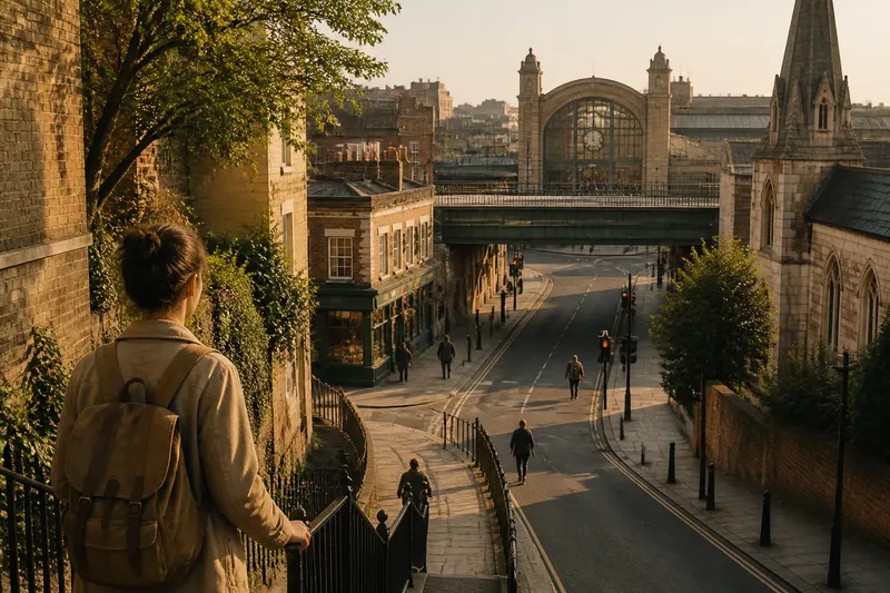
The common mistake is choosing a walking route because it looks like the shortest line on a map. That shortcut can cost you attention at every blank wall, awkward junction and uncertain crossing. A clear walking route is one you can understand as you move, using visible landmarks and turns that make sense on the ground.
Directness still matters: nobody wants needless detours. But a small bend past a recognisable church, a station entrance or a distinctive corner shop may be easier to follow than a straight stretch with few cues. Choose for the kind of street you are walking through, not just the shape of the line.
Start with your situation
Before choosing between two routes, ask what might make this particular walk difficult to read. Are you heading somewhere unfamiliar? Will you be walking after dark, carrying something, or navigating with a companion? Does the route cross a large junction or pass through an open area where direction can feel uncertain?
These questions are not about finding a universally best route. They help you spot where a route may demand extra decisions. A route with a little more distance can be the easier choice if it has stronger landmarks, fewer ambiguous turns or a crossing you can identify from a clear approach.
- If the area is unfamiliar: favour a route with distinct landmarks and turns that are easy to name.
- If you are in a hurry: check whether the direct route has confusing junctions that could slow you down.
- If you are carrying bags or walking with someone: look for a simple sequence of streets and crossings, rather than a route that depends on constant map-checking.
- If you will walk in low light: choose a route whose landmarks and crossing points remain easy to recognise, while following local safety advice.
- If you know the neighbourhood: your familiar shortcuts may be easier to read than an unfamiliar, more direct alternative.
Use this as a quick filter, not a rigid rule. The same route may suit one person and frustrate another, depending on familiarity, pace and the task at hand.
For unfamiliar streets
When you do not know the area, look for landmarks that stand out from several directions. A clock tower, a station forecourt, a church, a canal bridge or a building with an unmistakable entrance can help you confirm where you are. A useful landmark is not merely noticeable; it helps you make a decision or check that you are still on course.
Prefer landmarks tied to a specific turn. “Turn left at the red-brick library” is easier to picture than “continue until the street changes”, especially if the street name is hard to see or several roads meet close together. A route can be slightly less direct and still feel simpler when its instructions connect to visible features.
Do not rely on a landmark that appears only after you have passed the point where you need to turn. Before setting off, check whether you can see it from the approach, or whether a map makes its position clear. If it is hidden behind buildings or trees, choose another cue.
For long straight stretches
A straight road can be easy to follow if it offers a steady sequence of cues: a row of shops, a railway bridge, a broad crossing and a recognisable destination ahead. It becomes harder to read when every block looks much the same, street names are difficult to spot, or the view is interrupted by walls and construction hoardings.
On a featureless stretch, break the walk into smaller sections. Pick a visible crossing, a corner with a distinctive frontage or a point where the street changes character. These are checkpoints, not reasons to stop at every block. They give you a chance to confirm your direction without treating the entire road as one long, vague instruction.
For example, say you are walking through an unfamiliar business district and your map offers a direct route along a long street with plain office façades. You notice that a slightly bending route passes a railway bridge and then a station entrance. Choosing those visible cues may make it easier to tell whether you are still heading the right way, even if the walk is less direct.
For complex junctions
At a junction, a route that seems straight on the map may require a choice between several forward-looking streets. A bend can sometimes be clearer: turn towards a landmark, cross at a recognisable point, then continue along a street with a distinct frontage. Think about the decision you will face at the junction, not just the angle of the route line.
Check the approach as well as the crossing. A broad intersection may have several crossing points, while a small turning could be easy to miss from the pavement. A route is easier to read when you can identify which corner to reach and what feature to look for afterwards. Follow signs and crossing arrangements on the ground rather than trying to force a mapped line through them.
Where a junction is confusing, use one clear decision at a time: reach the named crossing, cross to the intended side, then look for the next landmark. Avoid instructions that string together several turns before you can confirm the first one.
When is a direct route clearer?
Is the shortest route always easiest to follow?
No. A direct route can be difficult if it runs through repetitive blocks or presents several similar-looking choices. It is a good fit when the street is legible and its crossings are straightforward.
Which landmarks help with walking directions?
Choose features that are distinctive, visible from the route and close to a decision point. A bridge, station entrance or unusual building is more useful than a feature that is easy to confuse with its neighbours.
Should I trust a map or what I see?
Use a map to understand the route and check your position, then use the street itself to choose a safe, accessible way forward. If a crossing or passage differs from the map, follow the signs and conditions you can see.
What if I keep checking my phone?
Pause somewhere that does not obstruct other people and check the next turn rather than trying to walk while reading. Then use one visible landmark to confirm that you are moving in the intended direction.
For repeated journeys
Once you know an area, the easiest route may change. A direct street that was difficult on your first visit can become familiar, while a landmark-based detour may no longer help. On a regular journey, notice which turns you remember without checking a map and which ones still prompt hesitation. That tells you whether the route has become readable to you, rather than merely familiar as a line on a screen.
If you are guiding someone else, use directions that describe both the action and the cue: “cross at the lights, then turn towards the station entrance.” Avoid relying only on left and right when the person may be approaching from a different direction. Agree on the next landmark and let the rest of the route unfold as you reach it.
It is not worth trying to memorise every street name or planning a landmark for each block. Too many cues become another list to manage. Pick the turns where confusion is most likely, and keep the rest of the route simple.
Choose the route you can read
For a familiar walk on a clear, continuous street, the direct option may be the simplest. For unfamiliar neighbourhoods, repetitive blocks or complicated junctions, look for a route with landmarks that support each important decision. Before setting out, compare the map with the street-level cues you expect to see, then choose the path you can follow with the least uncertainty. A clear walking route is not necessarily the shortest; it is the one whose turns you can recognise as they arrive.